آخر المواضيع المضافة

 النبات
الحيوان
الأحياء المجهرية
علم الأمراض
التقانة الإحيائية
التقنية الحيوية المكروبية
التقنية الحياتية النانوية
علم الأجنة
الأحياء الجزيئي
علم وظائف الأعضاء
الغدد
المضادات الحيوية
النبات
الحيوان
الأحياء المجهرية
علم الأمراض
التقانة الإحيائية
التقنية الحيوية المكروبية
التقنية الحياتية النانوية
علم الأجنة
الأحياء الجزيئي
علم وظائف الأعضاء
الغدد
المضادات الحيوية| Continental Drift |


|
|
Read More
Date: 1-11-2016
Date: 6-11-2016
Date: 29-10-2016
|
Continental Drift
PRESENT POSITION OF THE WORLD'S CONTINENTS
One of the most important factors in determining the climate of a region is that region's latitude. Near the equator in the tropical zone, climate is warm and humid, but a region located either to the north or south is exposed to cooler, drier conditions.
If the continents occupied different positions, they could cause the whole Earth to have an altered climate. The presence of the large continent of Antarctica at the South Pole allows huge amounts of fresh water to accumulate there as snow fields and glacial ice, lowering sea levels and exposing more land surface. It also increases ocean salinity by trapping fresh water for thousands of years. Increased salinity increases seawater density, affecting oceanic circulation and sea level. If Central America did not exist, water could circulate between the Pacific and Atlantic Oceans, resulting in new oceanic circulation patterns that would affect heat distribution to the poles.
The climate of a land mass is also affected by its size, shape, and presence of mountains. If a continent is small and flat, moist oceanic air can blow across it and bring precipitation to all parts. If it is large and flat, the central regions are too far from the oceans to receive much moisture, most of it having fallen as rain or snow closer to the coastline. The center of the giant continent of Eurasia suffers this fate. Mountains create rain shadows if located on the side of the continent close to the source of wind. The United States would be more moist if its highest mountains were in the east or if it were located farther south where the northeast trade winds could bring moisture in across the low Appalachians and Adirondacks.
PAST POSITIONS OF THE WORLD'S CONTINENTS
Cambrian Period. During the Cambrian Period, while all life was still aquatic and nothing lived on land, several separate continents were distributed in a vast ocean (Fig. 1a and b). Eurasia consisted of either one continent or two that were already close and moving together; the collision of Western Europe with eastern Europe and Asia apparently caused the formation of the Ural Mountains. This ancient land mass, whether one or two continents, was also farther south than at present, located in a warmer climate.
In the Southern Hemisphere was a giant continent called Gondwanaland; it was composed of South America, Africa, India, Australia, and Antarctica. Gondwanaland was constructed such that South America and Africa were attached, and Brazil and northwest Africa were located at the South Pole. The rest of the continent extended northward toward the tropics, but on the opposite side of the world from North America and Eurasia.
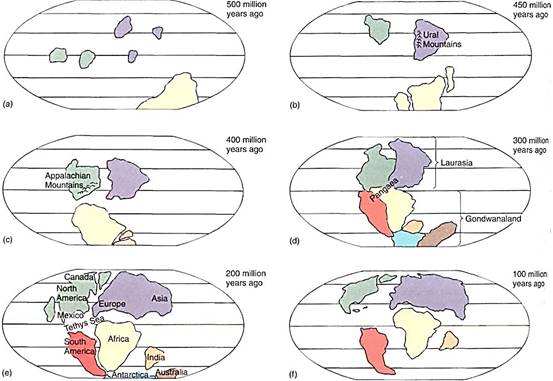
FIGURE 1: The continents have changed not only position, but size, shape, and profile as certain areas rise into mountain chains and other areas are covered by ocean when the sea level rises because of polar ice cap melting. Oceanic circulation changes as continents deflect or channel current movement, and this affects both transfer of moisture to the atmosphere and precipitation patterns.
Middle and Late Paleozoic Era. At about the time life was beginning to move onto land and rhyniophytes were evolving, the continents drifted together (Fig. 1 b and c). First, during the Silurian Period, North America collided with Eurasia, forming the Appalachian Mountains, which have almost entirely eroded away in the intervening 400 million years. This new continent is known as Laurasia. Next, Gondwanaland moved north and ran into Laurasia, pushing up the Alps. Virtually all land on the entire globe was located together as one supercontinent, Pangaea. The Laurasian portion was still in the tropics, and much of Gondwanaland was in the southern temperate and polar regions.
Pangaea, which existed for millions of years, through the end of the Paleozoic Era, had a diverse climate. The Laurasian portion was warm, moist, and tropical, whereas southern Gondwanaland was frozen and heavily glaciated. Large regions were swampy lowlands. Initially, Pangaea must have been relatively flat, but the collisions caused the formation of extensive mountain ranges in its center: the Appalachians and the Urals, as just mentioned. These must have caused rain shadows in the interior of Pangaea, and its enormous physical dimensions would have caused the central regions to be dry anyway. It was in the diverse conditions of Pangaea that most major groups of land plants arose: the Aneurophytales, Trimerophytophyta, and Archaeopteridales appeared during the Devonian Period as Pangaea finished forming, and the diversification of the horsetails, lycopods, Medullosales, and Cordaitales occurred during the Carboniferous Period.
Mesozoic Era. In the early Mesozoic Era (the Triassic Period), just after the Permian Period, the climate worldwide may have warmed. There is no evidence of glaciation any- where, although the Polar Regions did remain cool; away from the poles, the climate was warm and equable. Many new plant groups evolved at this time: Caytoniales, Cycadeoido- phyta, Cycadophyta, and Ginkgophyta. Ferns increased in number, but many of the first major groups started to disappear. As the Triassic Period continued, the climate became more arid; the Triassic Period is the driest of all geological times. By the time of the Jurassic Period, Pangaea had many contrasting climates: the North American and Gondwanaland sections were arid, but the western Eurasia region was less so. Humid zones occurred in Australia and India, as well as in central and eastern Eurasia.
In the Jurassic Period, Pangaea began to break up; the North American segment moved northwestward. Once separation from Eurasia occurred, the north Atlantic Ocean formed, producing a maritime influence on the two new coasts. Eurasia also began moving northward, separating from the southern portion of Pangaea. This resulted in the formation of a waterway, called the Tethys Sea, between the northern and southern continents. This area had alternated between marshy swampland and a shallow coastal sea, but with continental separation, the Tethys Sea became deep, and oceanic circulation between southern and northern continents could occur on a large scale. The northward movement of the North American and Eurasian continents brought them out of the tropics and into the temperate zones, their northern regions extending into the north polar zones. Conifers evolved and spread throughout the regions that were becoming cooler and moister.
At about the same time, the Antarctic-Australian segment separated from the rest of Gondwanaland, and later Australia broke away and moved northward into the South Temperate Zone (Fig. 1 e and f). India separated from Africa and moved rapidly over a long distance. At the time of separation, India was located at the edge of the south temperate zone (about 30 degrees S latitude) and had a flora adapted to such a climate. But it migrated rapidly, in just a few tens of millions of years, into the tropics, across the equator, and into the north temperate zone. The rapid fluctuation of climate in less than 70 million years was too much of a disturbance, and massive extinctions occurred. Once it arrived at the Eurasian continent, the two collided, forming the Himalayan mountains. As the two continents neared each other, plants could invade the foreign territory, some migrating northward onto the mainland, others spreading south from Eurasia onto India. This was to the detriment of India; its flora and fauna had not yet had time to become well adapted to the conditions of the north temperate zone, whereas the invaders from the mainland were well adapted.
In the Cretaceous Period, about 110 million years ago, South America separated from Africa, forming the southern Atlantic Ocean and allowing more humid oceanic air to reach west Africa. Until the break-up of Pangaea, Africa had the misfortune of being the dry center of the supercontinent. Its climate was so arid and severe that it had few species of plants or animals. With the formation of the Atlantic Ocean, Africa's climate became much more humid and conducive to plant growth, but even today the continent as a whole has many fewer indigenous species than one would expect if it had had a mild climate for a longer time.
Most continental pieces remained close together long enough for many newly evolved groups to migrate to most of the continents. The break-up of Pangaea occurred just as the flowering plants were becoming established, but as the North and South Atlantic Oceans widened, gene flow between the continents was reduced, and each developed unique floras. For example, the central deserts of Gondwanaland would have been ideal for cacti, but no cacti occur naturally in Africa, only in the Americas. The cactus family did not evolve until after the South Atlantic was wide enough to prevent the dispersal of cactus seeds from South America to Africa.
The latest major event in continental drift was (is) the collision of South America and North America. The two are coming together, and as always happens when continents collide, a mountain range forms. This collision started so recently, about 5 to 13 million years ago, that the mountains are short and are mostly still submerged below sea level. Only their tops protrude and are known as Central America and the Caribbean Islands. The formation of Central America created a continuous land bridge between the two continents, allowing plant species to be interchanged.

|
|
|
|
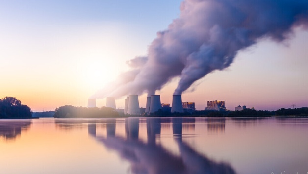
اكتشاف تأثير صحي مزدوج لتلوث الهواء على البالغين في منتصف العمر
|
|
|
|
|
|
|
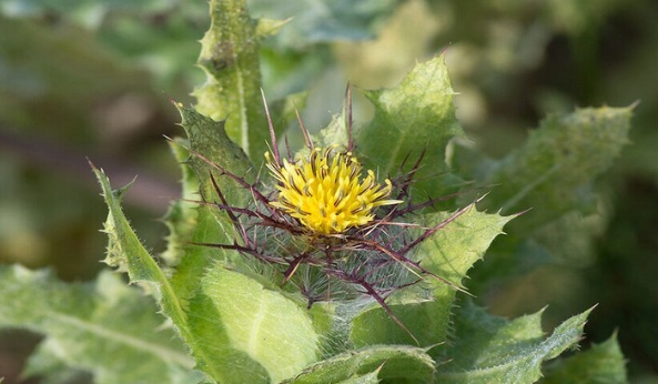
زهور برية شائعة لتر ميم الأعصاب التالفة
|
|
|
|
|
|
إدارة معرض النجف الدولي: العتبة العباسية أثبتت دعمها للمنتج المحلي برفعها شعار (صنع في العراق)
|
|
|
|
تعزيزًا للوعي القرآني.. العتبة العباسية تقيم برنامج (في رحاب الكرام)
|
|
|
|
العتبة العباسية تشارك في فعاليات معرض النجف الأشرف الدولي للتسوق الشامل
|
|
|
|
جمعيّة العميد وقسم الشؤون الفكريّة تدعوان الباحثين للمشاركة في الملتقى العلمي الوطني الأوّل
|